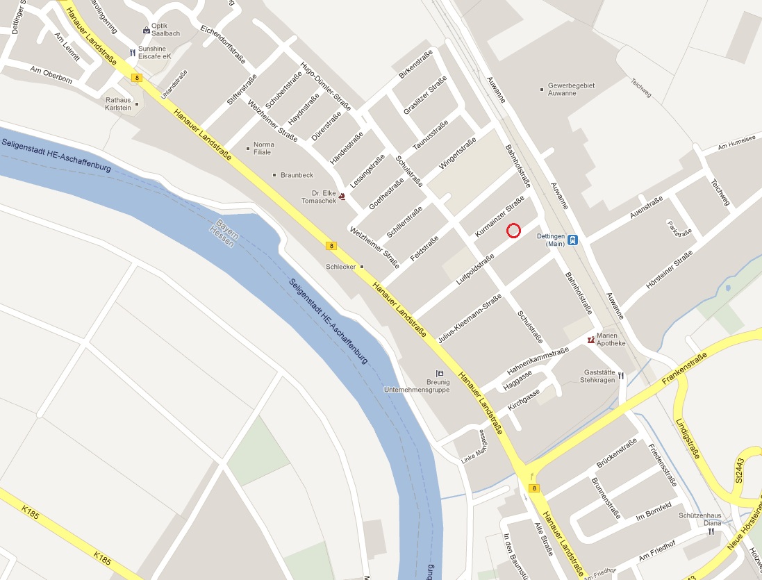
Karlstein - our Base Camp
Coordinates |
N 50° 02,569' E 009° 02,092' (our house) |
Height |
113,0 m over sea level |
Location |
Karlstein is located at the north west border of a natural region which is called Spessart. Our village is about 15 km north west of the district town Aschaffenburg. The lower frankonian village, which was founded in 1974 during a conclusion of the two independend villages Dettingen and Großwelzheim has about 16.000 citizen. Because the village is located to at the eastern border of the economic center of Germany which is called Rhein-Main-Area the connections to Frankfurt and the other cities of this area are quite good in the same way than you have here an ideal location to visit countryside places, go cycling or hiking at Spessart or do paddling on the river Main.
More informations, like something about history, you can find here: |
Climate |
The climate is moderate, a typical middle europe climate with oceanic based influences. Main wind direction is west. Because Karlstein is located in the Main valley the climate too is a bit more warm than other parts in Bavaria. Because of that Aschaffenburg is called too the bavarian Nice. See below the climate data from the german weather service in Offenbach am Main: (1) Middle annual temperature in ° Celsius |
Current Weather |
|
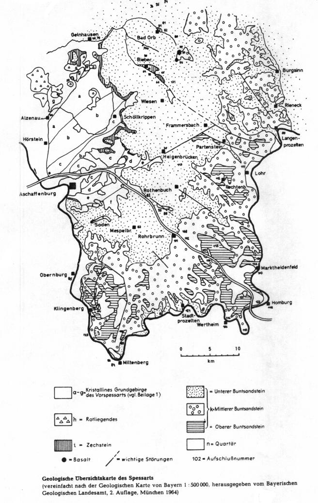
Geology |
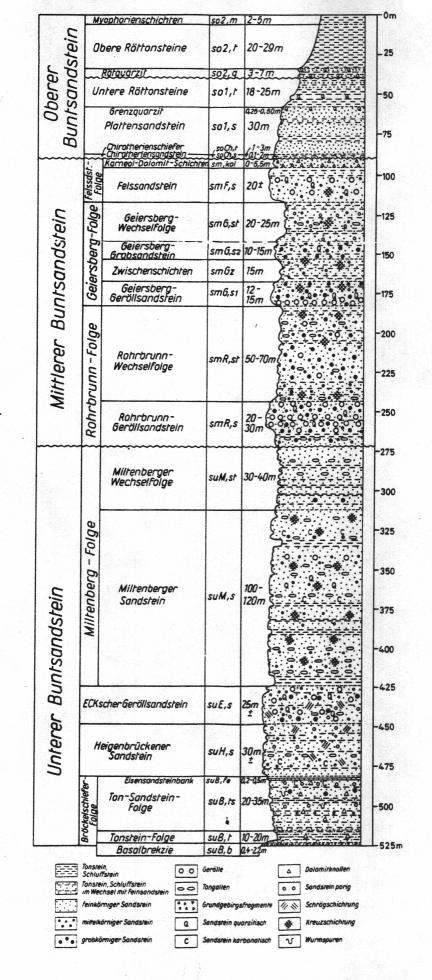
-- Lower Main Valley -- (a) Pleistocene aeolian sands and dune sands (b) Pleistocene terasse brashs (c) Redlying (d) Zechstone -- Spessart - Odenwald -- In the closer surrounding of Karlstein you will find just the following stone zones, who will be explained more in Detail. (The declarations are from the geological Map, Page 5920 Alzenau i. Ufr from OKRUSCH, STREIT und WEINELT): (b) Zone of staurolith containing Paragneis (c) Zone of corny - fibered Muscovit - Biotit - Gneis Normal profile through the Coloured Sandstone of the bavarian Spessartby P. CRAMER (geol. shot: Highwayprofile a. Drilling Trennfeld),
|
Soils and types of the location |
Because the author had no other data, than the ones he took during his forest job training, this describtions are based on the so called Location description (Standortsoperat) of the city Alzenau i. Ufr. and few soil samples he took to that time at the forest of the village Karlstein am Main. - Lower Main Valley -- -- Basement Rock Spessart -- |
Flora |
-- Lower Main Valley -- 1. Natural Forest Communities On the poor sand soils of the lower Main Valley, would, depending on the water household and geology, grow beech-/oakforests (mostly with mountain oak), beech forests, birch-/oakforests, beech-/oakforests (mostly with common oaks), common oak-/hornbeam forests and beech-/birch-/common oak forests. Parts at the so called Stift Striet and at the private forest Emmerichshofen let you see that formarly forests. 2. Current Forest Communities Today at lover Main valley pine trees are the leading trees. Often you will find pure pine tree forest. Mixed forests with pine tree and beech (pine trees are the upper part of those forests and beech grow just beside) you can find as well. 3. Forest historical reasons of this Communities The forests in region lower Main valley was owned in the 17th century by the so called Freigerichter villages. The citizens owned Woodrights and rights for pasture lands (written down in Forest regulations). Those historical forests consist nearly complete of oak- and beech forests . Because of to much lumber and pasture, because of the 30 year war, those forests was fully destroyed and partly transfered to fields. By removing and destroying of the humid surface of the forest soil, the sands was blown away and the fields beside was destroyed too. With raising complaints about the situation of the forest, begin of the 19th century first plants was set to recultivate the destroyed forests. At the begin additional to the pine trees Acacias, Willows and Poplars was planted. Because this hardwood was used to feed animals of the ones who had pasture rights more and more crops of pine trees was brought out. Result are the pine trees you see at lower Main region. But meanwhile the forest officers do and did a good job so slowly you see much more hardwood in that forests. -- Basement Rock Spessart -- 1. Natural Forest Communities On the Silicium and Gneissoils, and on the loam covered soils of the Hahnenkamm region as well, would grow, depending on the water household and geology, mountain oak tree-/beech forests, pure beech forests, beech-/oakforests (mainly with common oak) with pass over to common oak tree/hornbeam forests, beech-/hardwood forests (with ash trees and maple trees) and ash tree/elder tree forests. 2. Current Forest Community The current Forest Community is more or less like the natural one. Only in the parts which was reachable very good for humans (in the river valleys, lower parts with less declination) you will find forests with Larch, Pine trees (often with beech) and common spuces and douglas fin mixtures. 3. Forest historical reasons of this Communities The forests at the Hahnenkamm region was partly owned by the Freigerichter villages too. Because they was more far away from the villages and because of there strong declinations they was not so intersting for human use. But you will see here forest destroying as well. After the 30 year war and the intensive growing of the people more and more wood was needed and beeches and oaks cannot recover that fast, so more pine trees and common spuces was planted. On some parts you can see the using of leaves for bring to the staples of the people to this time. |
Fauna |
Sorry, but our region has from a faunistic perspective nothing special. The animals here are typical for middle european areas. Biggest mammels are the wild pig and the red buck with all the typical problems of cultivated landscapes. But there are some projects, like in other parts of germany too, who take care that gone animals can come back to the regions they live before. A good example for that is the repatriation of the european wild cat. At the deeper Spessart regions you can find meanwhile hints that the cat comes back. Project rescue net wild cat Finally you will find in our region too some animals which came from other countries, like the Racoon. So you can see, best is, walk a little bit through our fields and forests and look for the animals. |
Other interesting places surround Karlstein |
What should I tell you more about our really intersting landscape, villages and towns. Maybe you will discover more by yourself. Examples are the Pompejanum in our district city Aschaffenburg, the Stiftbasilica, one of the prettiest castles of the Renaissance, the castle Johannisburg. For the ones who are not so interested with villages and towns maybe hike a bit through our grape hills and enjoy a glas of wine. But below we will post here some guides for cayaking, hiking, roller blading and so on. Have fun and enjoy. |
Some pics from our house and the changes, which happened |
||
| Link to our "Basecamp" Gallery |