| |
|
| |
| N 50° 02,569' E 009° 02,092' (our house) |
| |
| 113,0 m over sea level |
| |
| Karlstein is located at the north west border of a natural region which is called Spessart. Our village |
| | is about 15 km north west of the district town Aschaffenburg. The lower frankonian village, which was |
| | founded in 1974 after a conclusion of the two independend villages Dettingen and Großwelzheim. The |
| | village has about 16.000 citizen. Because the village is located at the eastern border of one of the |
| | economic centers of Germany, which is called Rhein-Main-Area, the connection to Frankfurt and few other |
| | cities in this area are quite good. In the same way to those connections, you will find here an ideal place |
| | for visiting countryside places, like go cycling or hiking at Spessart or do paddling on the river Main. |
| |
| |  |
| |
| | More informations, like details about the villages history, you can find here:
|
| |
| | - Municipal of Karlsteins (German only) |
| | - Homepage of Nature Park Spessart (German only) |
| |
| The climate is moderate, a typical middle europe climate with oceanic based influences. Main wind direction |
| | is west. Because Karlstein is located in the Main valley the climate too is a bit more warm than at other parts |
| | in Bavaria. Because of that Aschaffenburg is called the bavarian Nice. below the climate data from the |
| | german weather service in Offenbach am Main (values are from the 80th): |
| |
| | (1) Middle annual temperature in ° Celsius |
| |
| | Mainvalley (Kahl 116 m over sea): 9,0 |
| | Valleys at about 200 m over sea: 8,5 |
| | Hills above of 400 m over sea: 8,0 |
| |
| | (2) Middle temperature movements in ° Celsius |
| |
| | Mainvalley (Kahl 116 m over sea): 18,3 |
| | Hills at about 330 m over sea: 17,7 |
| |
| | (3) Middle annual rain amounts in mm |
| |
| | Mainvalley (Kahl 116 m over sea): 680 |
| | Hills at 330 m over sea: 820 |
| |
| | (4) Mid date of the first and the last frost |
| |
| | Mainvalley (Kahl 116 m over sea): 8. May, 15. October |
| | Hills arround 330 m over sea: End April, Mid Oktober |
| |
| Weather at Karlstein |
| |
| -- Lower Main Valley -- |
| |
| | In the area of the Lower Main Valley, those are the regions close to the river Main, you can find the following |
| | geological units: |
| |
| | (a) Pleistocene aeolian sands and dune sands |
| | (b) Pleistocene terasse brashs |
| | (c) Redlying (german: Rotliegendes, Perm) |
| | (d) Zechstone (german: Zechstein, Perm) |
| |
| | (a) Pleistocene aeolian sands and dune sands |
| |
| | The aeolian sand has, specially northern and southern of the river Kahl a big extension. During Quaternary a |
| | lot of sands was blowing out of the terasse brashs and accumulated at the so called lower terasse (german: |
| | Niederterasse). Close to the town Alzenau, specially northern of the town, the sand carpet reach far until |
| | the higher areas and cover parts of the mid terasses (german: Mittelterasse) and of the so called Rothen- |
| | Berg-Terasses. Zechstone and Redlyings are enframed as well and partly covered too. At many places on |
| | top of that you will find dune sands. |
| |
| | (b) Pleistocene terasse brashs |
| |
| | Pleistocene terasse brashs you can find in the region eastwards of the river Main in large areas. But most of |
| | them are covered with big amounts of the aeolian sands. |
| |
| | (c) Redlying |
| |
| | At the northern border of the area of the town Alzenau there is a big area or Redlying located. This extension |
| | is a young palaeozoic sedimentation, consitent of Quarz, Quarzit and Limonit. The redlying stones are light |
| | red until violet colored and can be identified with that colors easyly. This colors come partly from the |
| | climate during sedimentation time, partly from the diagnestic transforms. The ceiling of this sediments is |
| | partly unclored. Such generations are called "greylyings", but can be found only in less parts. The |
| | redlyings are, with only few exceptions, covered with the aeolic sands. |
| |
| | (d) Zechstone |
| |
| | The sediments of the Zechstone you can see at some small places at the border of Spessart. It is shown as |
| | Zechstonedolomit or as a Zechstonepsephite. Those sources are very often covered by aeolian Sandceilings. |
| |
| | The informations above I took during my job training at the formarly Forest Office Aschaffenburg from the |
| | so called "Standortoperat" of the City Alzenau in Lower Franconia and was expanded by informations of the |
| | geological Map, Map 5920, with descriptions |
| |
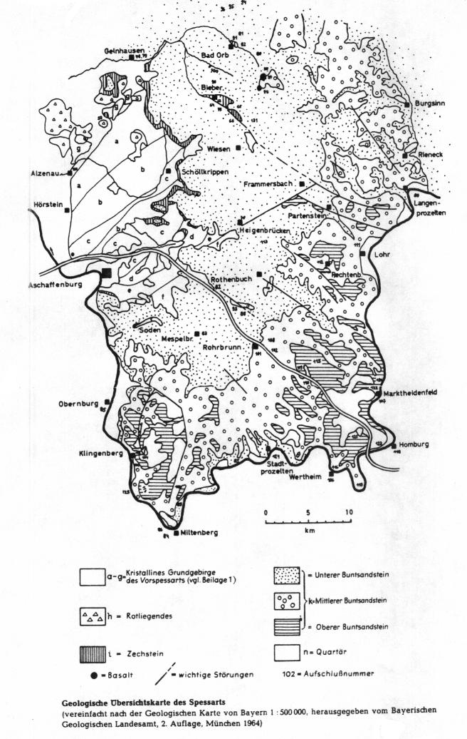
| | -- Spessart - Odenwald -- |
| |
| | Spessart and Odenwald are part of, on the border of the so called lifting region of the Rhein Valley, the |
| | northern saxonian-thuringaen Hillzone (Paleozoikum). The area is, because of that, from a geolocial |
| | perspective, one of the oldest regions in bavaria. The shown part of the surface is, like the name shows, |
| | the cristal, metamorphic basic stone underground and will be separated to the following stone zones by |
| | authors like BÜCKING (1892): |
| |
| | (a) Quarzit - Glimmerslade - Series |
| | (b) Zone of staurolith containing Paragneis |
| | (c) Zone of corny - fibered Muscovit - Biotit - Gneis |
| | (d) Glimmerslade - Biotitgneis - Complex |
| | (e) Corny - striped Paragneisseries |
| | (f) Diorit (Quarzdiorit) - Granodiorit - Complex |
| | (g) Gneises at the Northwest - Prespessart |
| |
| |  |
| |
| | In the closer surrounding of Karlstein you will find just the following stone zones, which will be explained |
| | more in Detail now. (The declarations are from the geological Map, Page 5920 Alzenau i. Ufr from |
| | OKRUSCH, STREIT und WEINELT): |
| |
| | (b) Zone of staurolith containing Paragneis |
| | (c) Zone of corny - fibred Muscovit - Biotit - Gneis |
| |
| | (b) Zone of staurolith containing Paragneis |
| |
| | All metamorph stones in the discussed area are sorted in to the varistic Orogenesis. After its composition |
| | the Staurolithgneis consists of Plagioklas, Silicium, Biotit and Muscovit as main parts, Staurolith and |
| | Granat as characteristic side parts. It is a common thesis that the stone before metamorphosis was a |
| | chalkpoor, pelitical (loose stones of poor and plotter's clay fraction) Sediment, like plotters clay. |
| |
| | The metamorphosis of the discussed Gneis has mainly the character of a kinetic Recristallisation |
| | Metamorphosis (isochemical run, means without chemical changes). |
| |
| | The geographical deviation of this zone in the area includes the area from the border of the city forest |
| | Alzenau-Hörstein in the northwest, so the village forests of Karlstein, Rückersbach and Kleinostheim |
| | until Steinbachvalley in the south. |
| |
| | (c) Zone of corny - fibered Muscovit - Biotit - Gneis |
| |
| | By timeline of the discussed area it must ranked prevaristic. The naming Gneis and most found one too is a |
| | middle corny fibred Gneis with Kalifeldspat, Plagioklas, Silicium, Biotit and Muscovit as Mainparts. |
| |
| | Because there are still rests of the Granit fabric are shown, this Gneis is nearly save a mesozonic minted, |
| | passive formed Granit. |
| |
| | Geographical the zone comes after the area we described before at its southern borderline. This means it is |
| | the area surround a bit southern from the village Glattbach and parallel to the Steinbachvalley. Local it can |
| | be found at the area surround of the hill Plattenberg (Karlstein) and eastwards of the so called Heißer Ackerhof. |
| |
| | Further there are at the so called Spessartborderbreak, the change over of the both growing areas (those are |
| | vegatational and geolocial parted regions) in small parts, often just as a relict, the following geological units |
| | we want describe only because of getting a complete overview, but not because they are important for the |
| | area. |
| |
| | (a) Sedimentations of the Palaeozoikum |
| | (b) Sedimentations of the Kaenozoikum |
| |
| | (a) Sedimentations of the Palaeozoikum |
| |
| | The whole Perm sedimentations who are described or shown in the map, so Redlying and Zechstone, are |
| | shown very seldom only as alteration relict. Because of that it must not be described more in detail. |
| |
| | (b) Sedimentations of the Kaenozoikums (here loam) |
| |
| | Loam is only shown in few parts who reach in the Spessartborderbreak like fingers. |
| |
| |  |
| |
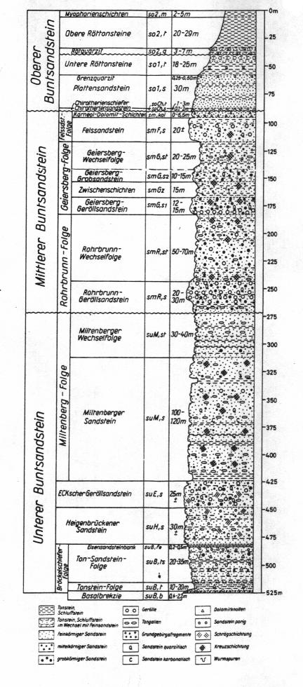
| Because the author had no other data, than the ones he took during his forest job training, |
| | this describtions are based on the so called Location description (Standortsoperat) of the city |
| | Alzenau i. Ufr. and few soil samples he took to that time at the forest of the village Karlstein am Main. |
| |
| | -- Lower Main Valley -- |
| |
| | The soils you can see in this area are most time podsolbased Brown Soils until really Podsols with a |
| | oecological wet level from try until moderate try until moderate fresh. As trophic level oligotroph until |
| | mesotroph will be reached. At the few locations which reach to the lower Main Valley you can find too |
| | Pseudogley-Brown Soils or Gleys with a oecolocial wet level of changing wet over fresh up to wet are |
| | from the trophic level "only" mesotroph. |
| |
| | -- Basement Rock Spessart -- |
| |
| | In this area you will find nearly invariably Brown Soils consisting of more or less sandy mud with an |
| | oecological wet level of moderate fresh. Because they are rich of minerals from the alteration process of |
| | the based stones I classify this Soils to a mesotroph (+) trophic level. At the tops of the hills there are |
| | partly Ranker, where the wet level might be a bit more bad and the trophic level might be a bit more bad too, |
| | what is shown with bad growing of the beeches there. |
| |
| | At the few loam locations on the break you will find few Parabrown Soils with wet and trophic levels like the |
| | locations with Brown Soils. |
| |
| -- Lower Main Valley -- |
| |
| 1. Natural Forest Communities |
| |
| | On the poor sand soils of the lower Main Valley, would, depending on the water household and geology, grow |
| | beech-/oakforests (mostly with mountain oak), beech forests, birch-/oakforests, beech-/oakforests (mostly |
| | with common oaks), common oak-/hornbeam forests and beech-/birch-/common oak forests. |
| |
| | Parts at the so called Stift Striet and at the private forest Emmerichshofen let you see that formarly forests. |
| |
| 2. Current Forest Communities |
| |
| | Today at lover Main valley pine trees are the leading trees. Often you will find pure pine tree forest. Mixed |
| | forests with pine tree and beech (pine trees are the upper part of those forests and beech grow just beside) |
| | you can find as well. |
| |
| 3. Forest historical reasons of this Communities |
| |
| | The forests in region lower Main valley was owned in the 17th century by the so called Freigerichter villages. |
| | The citizens owned Woodrights and rights for pasture lands (written down in Forest regulations). |
| |
| | Those historical forests consist nearly complete of oak- and beech forests. |
| |
| | Because of to much lumber and pasture, because of the 30 year war, those forests was fully destroyed and |
| | partly transfered to fields. |
| |
| | By removing and destroying of the humid surface of the forest soil, the sands was blown away and the fields |
| | beside was destroyed too. |
| |
| | With raising complaints about the situation of the forest, begin of the 19th century first plants was set to |
| | recultivate the destroyed forests. At the begin additional to the pine trees Acacias, Willows and Poplars was |
| | planted. Because this hardwood was used to feed animals of the ones who had pasture rights more and |
| | more crops of pine trees was brought out. |
| |
| | Result are the pine trees you see at lower Main region. But meanwhile the forest officers do and did a good |
| | job, so slowly you see much more hardwood in that forests. |
| |
| | -- Basement Rock Spessart -- |
| |
| | 1. Natural Forest Communities |
| |
| | On the Silicium and Gneissoils, and on the loam covered soils of the Hahnenkamm region as well, would |
| | grow, depending on the water household and geology, mountain oak tree-/beech forests, pure beech forests, |
| | beech-/oakforests (mainly with common oak) with pass over to common oak tree/hornbeam forests, beech-/ |
| | hardwood forests (with ash trees and maple trees) and ash tree/elder tree forests. |
| |
| | 2. Current Forest Community |
| |
| | The current Forest Community is more or less like the natural one. Only in the parts which was reachable |
| | very good for humans (in the river valleys, lower parts with less declination) you will find forests with Larch, |
| | Pine trees (often with beech) and common spuces and douglas fin mixtures. |
| |
| | 3. Forest historical reasons of this Communities |
| |
| | The forests at the Hahnenkamm region was partly owned by the Freigerichter villages too. Because they was |
| | more far away from the villages and because of there strong declinations they was not so intersting for |
| | human use. |
| |
| | But you will see here forest destroying as well. After the 30 year war and the intensive growing of the people |
| | more and more wood was needed and beeches and oaks cannot recover that fast, so more pine trees and |
| | common spuces was planted. |
| |
| | On some parts you can see the using of leaves for bring to the staples of the people to this time. |
| |
| Sorry, but our region has from a faunistic perspective nothing special. The animals here are typical |
| for middle european areas. Biggest mammels are the wild pig and the red buck with all the typical problems |
| of cultivated landscapes. But there are some projects, like in other parts of germany too, who take care |
| that gone animals can come back to the regions they live before. A good example for that is the repatriation |
| of the european wild cat. At the deeper Spessart regions you can find meanwhile hints that the cat comes |
| back. A further animal which was not seen in our region, but for sure which will be a part of our nature |
| soon again, will be the wolve. |
| |
| Finally you will find in our region some animals which came from other countries, like the Racoon. As you |
| can see, best is, walk a little bit through our fields and forests and look for the animals. |
| |
| What should I tell you more about our really intersting landscape, |
| villages and towns. Maybe you will discover more by yourself. Examples are the Pompejanum in our district |
| capitol Aschaffenburg, the Stiftbasilica, one of the prettiest castles of the Renaissance, the castle |
| Johannisburg. For the ones who are not so interested with villages and towns maybe hike a bit through |
| our grape hills and enjoy a glas of wine. |
| |
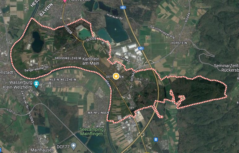
| But below we will post here some guides for cayaking, hiking, roller blading and so on. Have fun and enjoy. |
| |
|
| |
| Link to the pictures |
